


Transform any place with Nano Banana in Google Earth
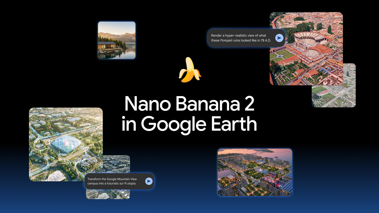
Transform any place with Nano Banana in Google Earth
Update, 7/31: We know that people uniquely trust Google Earth for a reliable view of the world. We’ve seen geospatial professionals using this feature for a range of useful purposes, however we’ve also seen people sharing screenshots of generated imagery that appear to violate our policies. So we’re rolling back this feature in Google Earth while we work on implementing stronger guardrails. It’s important to note that generated images didn’t appear in the main Google Earth experience for others to see and were watermarked as AI generated.
Original post, 7/30: Have you ever looked at an empty lot in your neighborhood and imagined a community garden, or wondered what your city looked like a century ago? Now Nano Banana 2’s image generation capabilities in Google Earth can show you both — and so much more.
For the first time, you can generate custom images using Google Earth’s satellite, aerial, and 3D imagery alongside Nano Banana, which creates concepts grounded in the real world. Just zoom in to a place in Google Earth on web, tap “create image,” and type whatever you want to see.
Here are five ways to try it.
1. Bring history to life.
Help students visualize the past instead of just reading about it. Teachers can show their classroom a historic site and type, “Render a hyper-realistic view of what these Pompeii ruins looked like in 78 A.D.” The modern-day ruins will instantly transform into a bustling, colorful street scene from the Roman Empire.
2. Learn more while you explore.
Create custom infographics to learn about a place without leaving Google Earth. Type, “Create an easy to understand infographic of the Statue of Liberty with key historical facts.” Behind the scenes, Gemini will retrieve relevant historical information and Nano Banana will create a graphic in seconds.
3. Create professional real estate plans.
Pitching a real estate project is much easier when your clients can visualize the final result. Architects and urban planners can now bring their plans to life by saying, “Reimagine this empty lot in Tokyo as a vibrant shopping and retail district with open spaces.” Barren concrete will be replaced by a high-quality 3D rendering of a bright urban oasis, helping your clients see what’s possible.
4. Visualize projects before breaking ground.
Whether you’re dreaming up a new backyard studio or your lakeside dream home, it can be hard to picture the final result. Now, you can visualize it quickly. Zoom in to an open lot and say, “Add a modern lakefront cabin built from sustainably sourced local materials” to see a photorealistic rendering of your future house nestled perfectly in the actual landscape.
5. Give your favorite place a makeover.
Sometimes it’s fun to let your imagination run wild. To see what a place might look like a hundred years from now, type “Transform the Google Mountain View campus into a futuristic sci-fi utopia with glowing walkways, glass biodomes, flying transport pods, and trees wrapped around buildings,” and watch the area morph into a vibrant, cyberpunk-inspired metropolis right out of a movie.
Image generation with Nano Banana is available globally today for Google Earth web users. Head over to Google Earth, pick a spot on the map, and start bringing your ideas to life.\
How to Use the Feature
- Open Google Earth on the web.
- Navigate, zoom, and adjust the 3D camera angle to your chosen location.
- Click the “Create Image” button on the interface.
- Type your text description into the prompt box and submit. [3, 4, 5, 6]
Top Ways to Reframe Locations
- Recreate History: Turn present-day ruins into bustling, historical cities (e.g., “Render a hyper-realistic view of Pompeii ruins in 78 A.D.”).
- Speculative Futures: Reimagine existing skylines, stadiums, or neighborhoods 100 years into the future.
- Urban Planning: Transform empty lots into community gardens, parks, or modern real estate concepts.
- Stylized Maps: Convert a realistic aerial scene into a black-and-white vector map or an infographic.
- Enhanced Visuals: Upgrade flat, low-resolution satellite maps into high-quality, drone-style photography concepts. [4, 5, 7, 8, 9, 10, 11]
Read more
. Google is signing the EU AI Act Code of Practice on Transparency of AI-Generated Content
. Gemini Robotics 2 brings whole body intelligence to robots
. NOAA and Google Cloud collaborate to advance weather forecasting.
. Google Workspace Weekly Recap – July 31, 2026
. Meet Qwen3.8-Max: A New Bar for Coding and Cowork
. 5 ways to host the ultimate dinner party with Google Search
. 5 ways AI Mode in Search helps you enjoy the real world
. These Google Trends show people really want to touch grass
. 2026-07-01 124 344 Codex Pets Meet The Team USEN YOUTUBE 1920×1080
. OpenAI’s New AI ASTRA Is Total Overkill (Ends The GPT Era)
. 3 new ways nonprofits can put AI to work
. Gemini API Managed Agents: 3.6 Flash, hooks, and more
. Provide more clear, contextual feedback with timestamped comments in Google Drive videos
. How Gemini Flash agents are helping a Michigan dairy farmer
***********************************************************
. Google Pixel 11 Pro Fold Open
. Gemini for macOS adds new natural language capabilities
. Visual screenshots now included in Google Meet meeting notes
. Streamlining rubric generation in Google Classroom with Gemini
. How to Build Apps and Automate Tasks with Google Antigravity 2.0
. Prepare for the holiday season with July’s Demand Gen Drop.
. What happens when you talk to AI
for more refer Gemini website click here
for more refer Artificial Intelligence website click here